Millions affected as stalled monsoon floods Thailand in 2026
Persistent rains and a stalled system left parts of Thailand under water in late September to early October 2026, with Landsat imagery capturing floodwaters and floating solar arrays.
Thailand faced prolonged flooding during the late September to early October 2026 period due to a stalled low-pressure system and heavy rains.
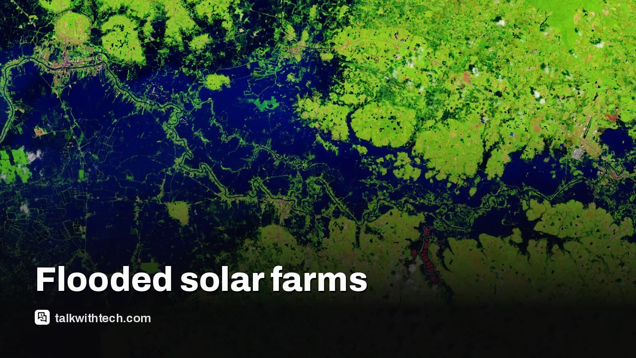
NASA’s Landsat imagery shows widespread floodwaters and floating solar arrays across Prachin Buri and surrounding areas.
The floods affected hundreds of thousands of hectares of farmland and impacted millions of people across 50 provinces.
This event highlights how monsoon patterns and warmer, moister conditions can intensify floods in Southeast Asia.
Quick read · 1 min
From late September into early October 2026, Thailand faced persistent floods driven by a stalled low-pressure system and heavy rainfall. NASA’s Landsat imagery shows widespread floodwaters across 50 provinces and highlights floating solar arrays on waterways. The floods damaged about 270,000 hectares of farmland and affected more than 4 million people.
The images offer a clear view of where water covers land and how floating solar projects intersect with flooded areas. While the event is far away, it serves as a reminder of how climate-driven rainfall can disrupt farming, transport and energy projects across the region.
What happened: Prolonged monsoon flooding in Thailand, October 2026.
Why it matters: Impacts agriculture and energy, with broader economic ripple effects.
What comes next: Weather monitoring, flood response, and longer-term resilience planning.
Floodwaters swamped large parts of Thailand from late September into early October 2026, intensifying as a stalled low-pressure system delivered persistent rains. The resulting floods spread across low-lying areas, submerging towns and agricultural land. In Prachin Buri province, fields, aquaculture facilities, and nearby land along the Bang Pakong River were inundated, with satellite imagery showing the extent of the flooding as it unfolded.
Two Landsat images compare the same areas across consecutive years, illustrating the severity of the 2026 flooding. The recent imagery uses false-color to separate water from vegetation and built areas, making it easier to see where water covers the land. Notably, bright red marks indicate floating solar arrays that have drifted onto flooded fields and waterways, underscoring how energy projects are adapting to flood conditions by using water surfaces that would otherwise sit idle.
Officials estimate that flooding touched 50 provinces and affected more than 4 million people. Farmland losses are substantial, with around 270,000 hectares reported damaged, including rice fields and fruit orchards. Bangkok-area rainfall was exceptionally heavy, with hundreds of millimeters of rain in a short period, a hallmark of the monsoon that climate patterns are making more intense over time.
NASA Earth Observatory’s Lauren Dauphin contributed the imagery, using Landsat data from the U.S. Geological Survey. The accompanying report highlights both the human impact and the changing environment in which flood management and planning must operate.
01
What the imagery shows in plain terms
The satellite pictures let scientists see where water covers land that isn’t normally underwater. The color scheme helps distinguish water from vegetation and built areas. Floating solar arrays, visible in the images, show how energy projects adapt to flood conditions by using water surfaces that would otherwise sit idle.
02
Why this matters for readers in the US, UK and Canada
Thailand’s floods are a reminder of how climate and weather patterns can drive extreme rainfall in Southeast Asia, which can disrupt global supply chains, agriculture, and energy markets. While this is happening far away, events like these influence commodity prices, shipping lanes, and can ripple through regional economies that trade with the United States, United Kingdom and Canada.
03
What happens next and how authorities respond
Weather agencies in Thailand will continue to monitor rainfall trends and flood forecasts. Local authorities are focused on rescue operations, evacuations where needed, and recovery planning for farmland and infrastructure in the hardest-hit areas. In the longer term, scientists will study how land use, drainage capacity and climate variability contribute to flood risk and how floating energy projects perform under flood conditions.
04
Practical takeaway for everyday life
For readers in the US, UK and Canada, the main impact is awareness. Severe flooding anywhere reminds us to check local flood forecasts, be prepared to adjust travel plans during the monsoon season or heavy rain events, and consider how climate change can alter seasonal weather patterns where you live.
Keep informed about weather alerts and travel advisories, and support resilient farming and floodplain management programs in your own region. If you’re near agricultural areas, follow local guidance about water safety and floodplain use. Community planning that factors in flood risk can help reduce damage when the next heavy rain hits.
Researchers report an experimental entanglement between a glass bead and a light beam, a stride toward practical quantum memory and new ways to store quantum information.
4 min read
We use cookies to understand how readers use Talk With Tech, so we can make it better. Is that OK? Privacy policy
The Daily Brief
Today's biggest tech stories, in 5 minutes
Every morning, the news that matters from AI, phones, apps and the people shaping tech. Explained in plain English. Free.
One email a day. No spam, unsubscribe anytime. Privacy policy