NASA 2026 El Niño could be the strongest since 1950
NASA says 2026 could host the strongest El Niño since 1950, with widespread effects from rain to drought across the globe.
Talk With Tech Newsroom
The short version
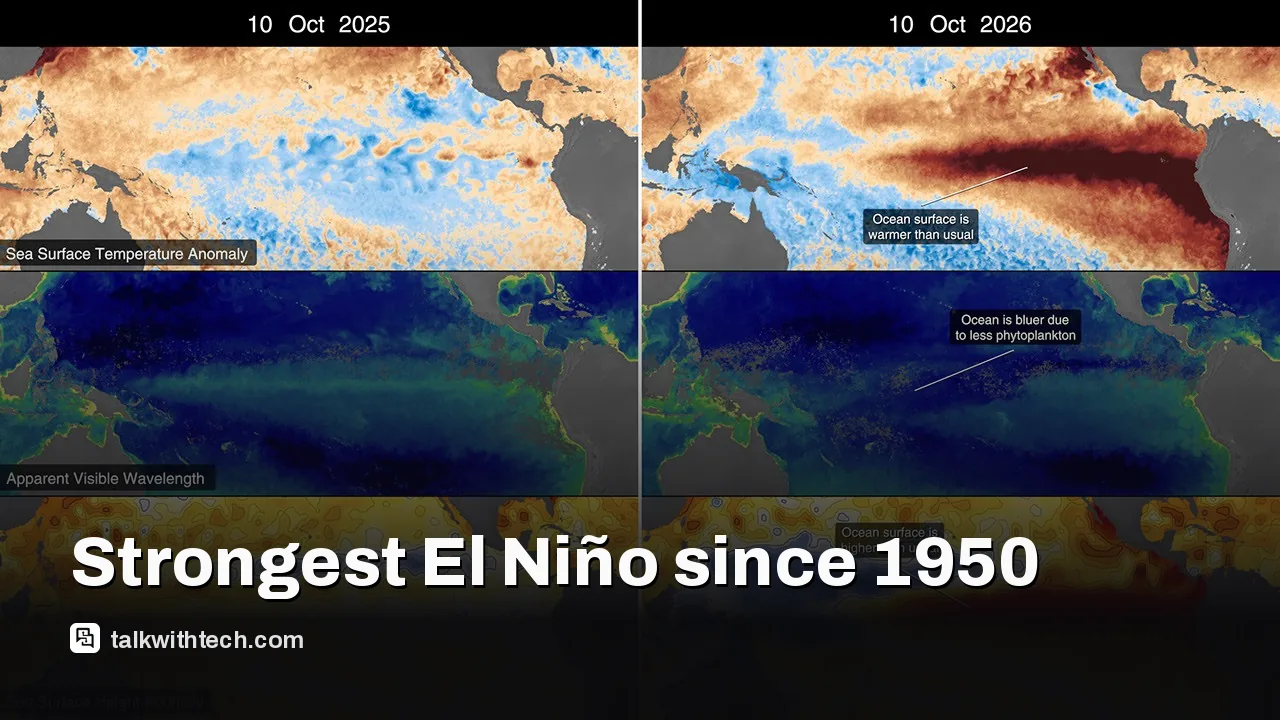
NASA satellites are monitoring El Niño 2026, guided by NOAA assessments that it may be the strongest since 1950.
Warm Pacific waters and Kelvin waves are driving shifts in trade winds, rainfall, and sea levels across the Pacific and beyond.
Changes in ocean color and heat distribution can influence weather patterns worldwide, with real-world effects for farmers, firefighters, and coastal communities.
Quick read · 1 min
NASA satellites are tracking a potentially record‑breaking El Niño in 2026. If confirmed as the strongest since 1950, it could reshape weather in many places, from rainstorms to drought. Kelvin waves moving heat across the Pacific, plus rising sea levels and changing ocean color, are the key signals scientists monitor.
What does this mean for you? More variable weather, potential flooding in some areas, and shifts that could affect farming, wildfires, and coastal communities. The good news is scientists are keeping a close eye with real‑time satellite data to improve forecasts.
What happens next? NOAA and NASA will keep updating their outlooks as the ocean continues to evolve, and more detailed regional forecasts will follow as models incorporate fresh satellite measurements.
NASA satellites are watching a rare, powerful El Niño unfold this fall. The agency says there’s a strong possibility this is the strongest El Niño since 1950, a pattern that can reshape weather from drought to floods around the globe. NOAA’s take is that the odds of this being a major event are currently high, and scientists are tracking the ripple effects as it develops.
El Niño describes a warming of surface waters in parts of the equatorial Pacific. It isn’t just a single storm; it’s a planetary climate rhythm that can flip trade winds, shift rainfall, and push sea levels higher in some regions. NASA’s satellites provide a front-row seat, measuring ocean heat, surface temperatures, and even the colors of the ocean to infer phytoplankton activity. Those observations help scientists forecast patterns that touch farming, wildfire risk, and coastal weather in the coming months.
Early clues appeared in January 2026 with a warm-water feature called a Kelvin wave near Micronesia. Kelvin waves are long pulses of water that move heat eastward across the Pacific. As these waves propagated, the eastern Pacific warmed and sea levels rose in some places, signaling the start of El Niño. By spring, the warming had spread further, and the ocean’s color signatures showed changes linked to phytoplankton patterns that accompany such events.
Scientists describe Kelvin waves as a key engine behind El Niño, carrying heat across the Pacific and helping to set the pace for climate shifts. NASA’s sea level satellites track how these movements influence coastal heights and storm tracks, giving forecasters better clues about coming conditions.
NASA’s Ocean Color Instrument on the PACE satellite is a key tool here. It measures hyperspectral color in the ocean, hundreds of wavelengths from visible to ultraviolet, to track phytoplankton and other surface changes. The data help scientists quantify how warm water and nutrients move, which in turn influences weather and climate models used by NOAA and other agencies.
So what does all this mean for the average reader in the United States, the United Kingdom, or Canada? The short version: El Niño can intensify or relocate rain and drought across continents. That can mean wetter winters in some regions and drier conditions in others, plus shifts in hurricane and storm activity. It also nudges sea levels and coastal flood risk, which matters to coastal communities and infrastructure planning. NASA will continue to share updates as more data come in, including how the Pacific’s heat pattern evolves and how far it reaches into global weather systems.
The 2026 El Niño comes with built-in uncertainty. While NOAA currently signals a high likelihood of a strong event, the exact strength and timing can shift as the season unfolds. Scientists emphasize that ongoing satellite observations from NASA and the broader weather data network are essential to refining forecasts and preparing communities for shifting conditions.
For now, the takeaway is simple: this is a significant climate moment. Expect wetter or drier patterns to emerge in waves, with coastal regions watching sea levels and flood risk more closely than usual in the months ahead.
Rocket Lab confirms another hold on its medium‑lift Neutron rocket due to manufacturing issues with carbon composite tanks, pushing first flight into 2027.